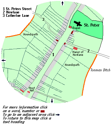
The triangular
Market
Place extended into
the wide St. Peters Street, described in 1245 as
the "great street" (magno vico) which goes
to the church of St. Peter. To the north of the
churchyard the street was known as Bowgate.
Below Newlane the properties on the eastern side of
the street generally stretched originally, back to
the defense of earthen bank and ditch known as
Tonman
Ditch or Monk Ditch,
but in the later Middle Ages those at the north of
this frontage stretched to the Manor of Newlane
(situated in Newlane). On the western side of the
street the properties immediately above the Market
place backed onto the northern side of Dagnall
street; further north they stretched originally to
Tonman Ditch on the western boundary of the
town. Like other street the limits
of this street seem to have varied. Some properties
described as being in St. peters street being in
the present Chequer Street. In 1444/5 the tenement known
as "le Fyshh" was being repaired and other named
tenements are "le Wolsack" (1446), "le Castell" and
"Le
Lambe" (1473).
"Bromleys" (1496/7) and the "Leyden Porch"
(1496/7). The Castle stood on the northern
corner with Shropshire Lane and it was here that
the Duke of Somerset died during the First Battle
of St. Albans in 1455. This street has seen much
redevelopment and today few medieval buildings
survive. click
for information on the church In the
south west comer of the churchyard, its position
still marked by some ancient masonry in the base of
the churchyard wall, was the chapel of the guild
known as the Fraternity of All Saints. This was
also known as the Charnel Brotherhood and its
chapel as the Charnel Chapel because of its
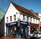
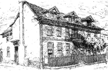
position in the church yard. One of the few medieval buildings to survive in
the street this building was more recently the
Queen Adelaide public House. It has a two storey
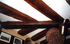
cross wing on the street with a hall behind The former Queen
Adelaide Dragon Beam to support jetty around the
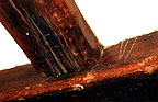
corner of the building Carpenters Mark "Scar" on joists of former beam supporting
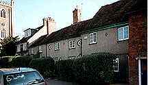
jetty Built as a house in the Fifteenth century, the
Cock still retains the two storey wing on the
corner of St. Peters Street and Newlane (Hatfield
Road). This was originally jettied along both
streets fronts and the "dragon beam" essential in
such a construction is visible. Also visible are
the joists for the upper floor on which a fine
series of carpenters marks are visible and the
position of the original stair well can be
determined from the pattern of empty mortises. (So
it's possible to enjoy a drink and study this
detail at the same time!) The hall range which once
stretched along Newlane was rebuilt in the
Seventeenth century. In 1496/7 Roger Porter left to his wife Alice
the remaining years of his lease on the tenement
called "the Mansion" in St. Peters Street which he
held of the master and bretheren of St. Julian's
Hospital. After the Dissolution the Mansion House
came into the possession of Sir Richard Lee and
there is a building in the street which still bears
this name. However I do not know if any medieval
structure remains. St. Peters Green Set by the entrance to the churchyard is a row
of buildings some of which date from the fifteenth
century. Now Hatfield Rd. and once
Cock Lane, named after the Cock (see above), it is
not certain when this lane was "new". It was
certainly so called in 1381 but is not mentioned in
the 1327 perambulation of the town boundary which
is described as running from Stonecross to the
corner to the corner of St. Peters Churchyard,
thence to the Grange of John, son of Richard
Baldewyn and thence by Tonman Ditch to Sopwell
Lane. However a Robert of New Lane (Nova
Venella) paid tax in 1307. John's grange would
have needed access so perhaps the lane was formed
to provide this and later extended beyond the town.
The way to Hatfield appears to have been via the
present Sandpit Lane In 1426 Abbot
Wheathamstead obtained a license in Mortmain for
the possession of 'unum messuagium vocatum
Newlane ' and the substantial estate that went
with it. This was given by John Bernewell, Edmund
Westby & Matthew Bepset. In 1429 the new post
of Master of Works was to be supported from
revenues including those from 'Squylers et de
Newlane ', and later these two estates became
known as the manor of Newlane (or Newland)
Squillers. Squylers
was granted a license in Mortmain in 1429 and was
granted to the Abbey by deed of gift by Roger
Husewyffe and Richard Bingham in 1430. It seems
likely that John's Grange recorded in 1327 was the
predecessor of the later "Newlane". The site of the
manor of Newlane was "redeveloped" in 1733 when the
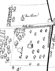
present Marlborough Almshouses were built. In his will of 1437 John Bernewell left to his
wife a croft called Dovehouse croft and a croft
"in front of the one belonging to the lord
Abbot, called Newlane, facing it from the other
side of the street ". Perhaps this Dovehouse
croft was where a Dovecot still stood in the C17.
(see map on right). Another 3 crofts in Newlane
where left by Edmund Westby in 1471. At some time in the early C15 John Ferrers,
steward to Henry Beauchamp, Earl of Warwick, gave
ten shillings of annual rent arising out of 4 tofts
in Newlane to St. Peters church. The Manor House of Newlane in 1634 with a
dovecot in its grounds and another on the opposite
side of the street Catherine LaneNow known as Catherine Street this is not mentioned in the 1327 perambulation of the town boundary. Its present course is much straighter than it was in earlier times. The 1634 map of the town shows no buildings here. It was by this route that Queen Margaret''s troops reached the top end of St. Albans to attack Warwick's Yorkist forces in the Second Battle of St. Albans in 1461 On the southern corner of the Lane, fronting onto St. Peters Street, was a property known as the Lamb. This was recorded in the will of John Wangford in 1473 and that of Robert Clothman in 1497/8 when it was described as a meadow and tenement in St. Peters Street. In later times this property belonged to St. Peters Church and the churchwardens accounts suggest that Lamb close ran along the southern side of the lane, the property being bounded on the west by Houndspath. In more recent times the building was a Public House with the sign of the Painters Arms.
|
|||||||||||||||||