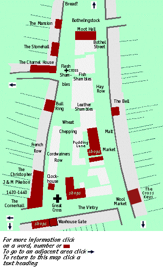
the Market Place

Note -the Eastern Side of the Market place, the Malt Market (modern Chequer Street) is discussed on a seperate page
Clicking on the relevant part of the map will take you there


The Market Place

The Medieval Market Place was much larger than the street which bears that name today. Originally it was laid out as a large triangular open space with its base along the south of the present High Street, its eastern side along the eastern frontage of the present Chequer Street and the western side along the western frontage of the present French Row/Market Place. At its northern end the Market place merged into the very wide St. Peters Street.
According to the Abbey Chronicles the Abbot Wulsin ( or Ulsinus ) "... loved the area of St. Albans and the people who lived there and sought to improve it. He made it possible for people to come and live there, bringing them together from the surrounding areas, adding to and enlarging the market, and also helped those constructing buildings with the cost of timber..." The date given for this activity is 948 although it is now generally considered that Wulsin's floruit was earlier, around 860-880.
Excavations between 1981-84 prior to the construction of the Christopher Place and Maltings shopping centres showed that the properties there abutting on the market place were not laid out before the mid-12th century so that the location of the original market place is uncertain. At the time of the Domesday Book (1086) the market tolls and other payments from the town were worth £11-14-0 a year. King Henry II (1154-89) confirmed to the Abbot "..the town of St. Albans with the market place and every liberty a borough ough to have.." and by 1287, at the latest, market days had become established as Wednesday and Saturday and so remain today.

By the later Middle Ages the open area of the original Market Place had become built over as temporary stalls were replaced by permanent shops, resulting in the pattern of streets and alleys in the area today. One such lane, Pudding Lane ("le Puddynglane") was certainly in existence in the mid-14th century.
Today traders of all descriptions occur at random throughout the market but this was not the case in earlier times. In 1245 Isabel, the wife of Michael, had a stall "where meat is sold" and in 1261 there is reference to "the street where iron is sold", and in 1250 Alice daughter of Droicons had a stall in St. Peters Street "where bread is sold". By the later Middle Ages the area was certainly divided into the Fleshshambles, the Fishshambles, the Leather Shambles, the Pudding Shambles, the Corn Market, or Wheat Chepping, the Hay Row, the Wool Market and the Malt Chepping and the general position of these is shown on the map. Shambles and Chepping meant market.


The Bull Ring

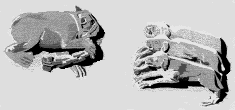
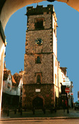
A Bear being Baited by Dogs

(from the Watching Loft in the Abbey Church)

In 1500 the fisherman John Hole left his tenement situated opposite "le Bollryng" and post-Medieval deeds show that this was situated in the area where in 1634 the pillory was situated. Perhaps the tormenting of man and beast took place in the same area in the middle Ages.
During the Peasants Revolt in 1381 a rabbit taken from the Abbots warren was hung on the pillory later to be replaced by the head of a man released from the Abbots gaol and who for some reason was not popular with the insurgents!

It was probably not only bulls who were baited in the Market Place for among the scenes of everday life which decorate the fifteenth century Watching Loft in the Abbey church is one showing an unfortunate chained bear being set upon by three ferocious dogs.

The Charnel House and The Moot Hall

In 1381 the St. Albans rebels were tried in the Moot Hall and also tried there was the "hedge priest" John Ball, one of the national leaders of the revolt. However there is no evidence that Ball had ever visited St. Albans before his trial; he was arrested in Coventry and brought to St. Albans because that was where the king was. In St. Albans the Old Town Hall is commonly referred to as the Moot Hall but Mr. J.T. Smith has shown that this building was built in the later sixteenth century as the town hall and it is now clear through the research of Mr. G. McSweeney that the Moot Hall occupied a different site altogether being, paradoxically, more or less where the present nineteenth century Town Hall is.
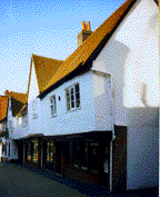
The original borough charter of Edward VI (1553) granted to the town the Charnel House otherwise the Town House for use as the town hall and this hall seems to have been the meeting place of the Charnel Brotherhood replacing an earlier guildhall on Holywell Hill which was also known as the Charnel House. It may be that this hall only came into being after the dissolution of the Abbey, (there is some evidence that it was not in use until after 1543) and that the Charnel Brotherhood played a leading part in the government of the town after the ending of the Abbot's rule and before the establishment of the corporate borough.

The Moot Hall was the building in which the Abbots court which dealt with the borough was held and from its position in the market it was no doubt also the venue for the "Court of Pie Powder" which dealt with market offenses. An alternative name for the building was the Stokhouse ('le Stokhouse alias dictum le Mootehall', 1535) and in some documents the Stokhouse is described as a shop. Presumably there was a shop below an upper hall.
In 1472 two shops were described as being in market where meat is sold, next to Bothelyngstock, between a shop on one side and the stockhouse on the other with one head abutting on the Kings highway and the other on a lane called Bothelestrete. A much later document shows that Bothelingstock was the lower end of St. Peters Street and Bothel Street was probably a lane running north-south situated between the Meat Market and the present Chequer Street.

The Stonehall

This building was so calle in 1543 but no trace of a stone building exists today. The present building was built in the early 18th century but part is an older 16th century timber framed building. This could however be the site of one of the stone halls which did exist in the medieval town.

The Cross Market or Cross Chepping

The Great Cross

An Eleanor Cross

Dominating the southern end of the market in the area now known as Market Cross was the Great Cross or Queen's Cross, the "Eleanor Cross", one of the series built to commemorate the resting places of Queen Eleanor's body on its journey from Lincolnshire to Westminster in 1290. This was completed in 1294 at a cost of £100, well over the estimated cost of £90. The master mason was John Battle who was also reponsible for the crosses at Northampton, Stony Stratford, Woburn and Dunstable. Of the twelve crosses built along the route of the cortege only three survive today and the illustration here is based on the surviving cross built by Battle at Northampton. The Cross was demolished in 1701 and there appears to be no contemporary illustration of it, except for a glimpse of the very top on the town map of 1634. The cross was clearly a focal point of the town for it was here that the insurgents in 1381 burnt muniments taken from the Abbey and later read out their short lived charter of freedom. It was here also that the "heretical" books of the Lollard Walter Redhed of Barnet were burnt after he recanted in 1426/7.

The Clockhouse

It was close to the cross that the Clockhouse or clocktower was built between 1403 - 1412, on a vacant plot of land, of about the size of a market stall. The architect was the sometime Royal Mason, Thomas Wolvey who at the time was living in the Abbey manor of Childwickbury. The original owners were Wolvey and John Penny but it was soon vested into the hands of feofees (trustees), at one time numbering 80 who seem to have been important members of the guild known as the Charnel Brotherhood, who probably at this time played a part in the running of the town. The building has 5 floors and two staircases, one entering from the street and continuing for the full height of the building; the other entered from the ground floor room and reaching the second floor before joining the other. This allowed the curfew bell to be rung and the clock maintained seperately from the occupancy of the lower two floors, which were designed to serve as a shop; the large ground floor windows being shop windows. The original bell cast at Aldgate, London between 1371 and 1418 was clearly made for the tower. Known as Gabriel, it bears a latin inscription reading "I have the name of Gabriel, sent from heaven".

The Clocktower

In 1420-1440

A Thorby was paid for work on a "tenement next to the Great Cross on the East" this was perhaps The Cornerhall/Lyon which in 1539 was next to the Fleur de Lys, although in post-medieval times there was a building beween the two which remained seperate until both buildings were demolished before the new Great Red Lion was built in 1896.

French Row/Cordwainers Row

The origin of this first name is unknown despite the local tradition that it derived from the quartering of French troops there in 1217. Although the name is applied today to the street it may originally have referred only to the row of buildings on the west, those on the east being Cordwainers Row although in 1403 the plot on which the clockhouse was later built is described as"in vico Francorum alias dicto Cordewaneresrowe" . However the property to the north of the clockhouse was through the 15th/16th century described as being in Cordwainers Row. The Nuns of St.Mary de Prae had one or two houses and a walled garden here and in 1420-40 Abbot Wheathampstead paid for the construction of a brewery in "vico vocato vulgariter 'Le Frenshrowe'".
Excavations prior to the construction of Christopher Place behind the western side of French Row/Market Place revealed the stone footings for 14th/15th century timber framed buildings perhaps use for industrial purposes. These overlay a complex of rubbish pits dug from the late 12th century onwards. This suppports the view that plots with a "head" on French Row/Market Place curved round to Dagnall Street. Certainly in 1539 Henry Webbe had a tenement in French Row which extended to Dagnall Street.

John & Matilda Pikebon

During the Abbacy of Thomas de la Mare (1349-96), John Pikebon and his wife Matilda gave to the Abbey their fine house in French Row, along with 2 acres of land, for the use of the abbey after their deaths. In 1386 John and Matilda acquired the vacant place on which the Clockhouse was later built, then descibed as opposite their capital tenement which had once belonged to Simon the Vyntner. Thus John and Matilda's house must have been where the Fleur de Lys is today. For some reason the St. Albans tradition is that King John of France was held in a predecessor of the Fleur de Lys after his capture at Poitiers in 1356. This is clearly nonsence because the property was not the Abbey's at the time and anyway a king would have merited better treatment than this; while confined at Hertford Castle he had a large part of his court with him. The Abbey's Chronicles of this date make no reference to the captive king in St. Albans although he and the Abbot were clearly acquainted. So no King John! despite the inn sign; although the Fleur de Lys was an inn before the dissolution of the Abbey, the present building was being rebuilt at around that time or slightly later. During the rebuilding of the adjacent Great Red Lion part of a window said to belong to the Fleur de Lys was discovered and dates from the 14th/15th century.

Fourteenth/Fifteenth century window from the Fleur de Lys


 The Christopher Inn

One of the towns oldest inns originally built around 1400 although much altered and enlarged over the years. Now used as shops and offices.

The Christoper Inn today

High Street

 Quite where High Street ended and Church Street began is uncertain: in the 15th century Church Street stretched to the Cross Market on the north and therefore probably to the Waxhouse Gate on the south although the situation does not seem so clear in earlier times. In the 15th century and later the area of the present High Street to the east of Waxhouse Gate was known as "The Vintry". This name survives in the present Vintry Garden part of which must occupy the area of the former Abbey vinyard. As in Church Street, by the mid 14th century serious encroachment had taken place onto the Abbey precinct although in 1302-8 Abbot John licensed Walter le Ferun (Smith) to build a house on the wall between the "Wynyerd" and his own house.


Waxhouse Gate 

Waxhouse Gate Today


Waxhouse Gate provided pedestrian access to the Abbey. A gate of this name existed in the mid 14th century and it was rebuilt between 1420-40 by Abbot Wheathampstead. Much of this gate still survives although it was extensively rebuilt with brick and new windows in the early 18th century. Today the gate passage passes under a round headed arch but this results from cutting back in the 18th century. Originally this was a pointed Gothic arch the springing of which can still be determined. The arch within the present shop front sometimes interpreted as an original vehicular access was most probably constructed when the ground floor shop was created.
In 1230-80 William Medici had a shop "next to the sacrist's gate"; the Sacrist's buildings stood immediately to the north of the north transept of the Abbey Church so that this might have been an earlier name for the gate.

hold mouse over for a map of the Abbey

17 High Street

17 High Street today and a possible reconstruction of its original form

Notable today for its pargetted front bearing the date 1665 this building was originally built as a lock-up shop around 1500. Originally the two upper floors were jettied over the street.

Until 1911 two similar shops stood to the west of No. 17 but these were demolished to make way for the building of a department store. No 17 was saved by public protest. Their site is now occupied by Heritage Close , prior to the building of which some interesting medieval finds were excavated, although the archaeology of the street frontage had effectively been removed in 1911.

  Nos.10-14 High Street 

Similar shops to those described above survive at Nos 10-14 High Street although these have been much altered. All these seem to have been lock-ups with no living accommodation as there appears to be no provision for heating.

Nos 10-12 High Street today