|
The modern Welclose Street
was known in the 15th century as School Lane
because of its proximity to the Monastic
School. On the western side of the street was
the toft of Squillers. A map of 1634 shows
the location of the parcel of land known as
Wellclose which was described in 1597 as "alias
Squillers", so giving its location, although
the property probably stretched to the street
front. Abbot Wheathampstead built a barn on the
property in 1438. His clerk Matthew Bepset also had
a tenement hereabouts which included a dovecot. In
1446 Master John Wheathampstead paid rent to St.
Mary's Sopwell for the toft of "Squylers".
It seems to have been this toft which was
amalgamated with the property known as Newlane to
form the Manor of Newlane
Squillers.
|
Originally this was a large
rectangular open space in front of the Great
Gateway of the Abbey, its name deriving from
room land (i.e. an open space). The Nunnery
of St. Mary de Prae held an annual fair here under
a charter granted to them by King John in 1199. It
was here that the rebels gathered in 1381 prior to
breaking in to the Abbot's prison in the Great
Gate. What is now Romeland Hill was known from at
least the 13th to 15th centuries as Hockerhulle
and it was this frontage that was built up.
This unusual name occurs elsewhere in Herts. at
Hockerill, the first element seemingly the Old
English hocer = hill or hump.
It was on Hockerhulle that the
Monastic School in existence
by 1100, was situated by the 13th century. In
1420-40 Abbot Wheathampstead repaired a
tenement"in the corner next to the Grammar
School" which means that the site of the school
is now covered by the 18th century Romeland House.
In 1497/8 Robert Clothman left a tenement with a
garden "lying upon Hokerhyll ageynst Scoille
Lane". In the 15th century there were shops
here as well as an inn known as "le Key".
This later became known as the Cross Keys (one of
two inns of this name in the town) and survived
until the 18th century.
Tankerfield
Place
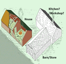
Excavation in 1978, prior to
the construction of this new development showed
that occupation began in the early13th century when
a simple two room peasant house, barn or store and
?kitchen were built. This setup looked very much
like the sort of agricultural holding seen in
villages of the time, although a farmstead opposite
the main entrance to the abbey might seem
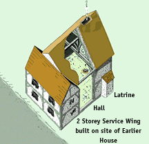
surprising. The house was rebuilt as a timber
framed hall house in the fourteenth century ans at
a later date a latrine with mortared flint shaft
was attached to the hall. The house was demolished
c.1450.after which the plot lay vacant for over a
century.
|
|
|
Reconsruction dawing
of the buildings built in the early 13th
century. The House and Barn were built
using earthfast posts, The
Kitchen/Workshop may have had simple clay
walls
|
Reconstruction drawing
of the house as rebuilt in the 14th
century. This was of timber-framed
construction and later a latrine was added
to the open hall
|
|
|
Concealed behind the 19th
century front are two surviving bays of a building
with crown post roof and original cellar, built
c.1400. This may have been the Key mentioned
above.
|
This street took its name
from the Abbey officer called the Spicer. In
1335-49 a tenement in Spicerestrete which
had been given to the convent by John de Harleston
was transfered to the abbey Almoner on certain
conditions for finding spicerey for the
convent.
The excavation on Romeland Hill also investigated a
small area immediately to the west of Spicer
Street. Here there was evidence of a building
probably used by a 13th century broonze
worker.
|
|
The Vine, sometime a public
House and still displaying its sign, was originally
built as a house in the second half of the
fifteenth century. The present house began as the
two bay open hall, with crown post roof, with a two
storied bay to the north. At the south end (now a
seperate property) there was probably once a two
storey cross wing although this part of the house
was rebuilt in the later 17th century.
|
|
|
|
The Vine
today and a conjectural reconstructioan
of thr Medieval House.
(plan
after Smith and Kilvington)
|
|
This street is now cut into
two - Upper and Lower Dagnall Street - by the 19th
century Verulam Road which opened in 1826. As it is
parallel with Romeland/Church Street there was a
marked diference in the amount of space available
on either side of the street. Indeed its seems that
building was generally confined to the northern
side of the street with Church Street properties
mainly stretching back to the southern frontage. As
elsewhere in the town this meant that buildings
were at the head of very long plots of land, much
of which could be used for agriculture. Thus in
1253 Reginald Trumpington had a messuage with two
strips of arable land to the north.
In 1349-96 John Gumbard and his wife Alice, gave to
the Abbey a tenement with 29 acres of land. In 1484
Margaret Wangford left "all my interest in the
lease which I have in Gombardes...." and
1496-7, the butcher Robert Porter, left to his wife
the remaining years of a lease "in a certain
field called Gumbardes held by me of Thomas Fisher,
baker". There were 20 acres known as
"Gumbedes" in 1545 and the name still
survives in the city as Gombards and Gombards
alley.
At the upper end of the street, on its southern
side, excavations in 1981 prior to the construction
of Christopher place showed that here the
properties curved round from French Row to back
onto the street. Here the only building was,
probably a shop, built at the end of the 14th
century, the rear bay of which contained a timber
lined cellar. In around 1480, sometime after the
building had been removed, the cellar was filled
with much rubbish including pottery imported from
the Netherlands, Germany and Spain.
At the lower end of the street, perhaps where New
England Street Playing Fields are now,was an area
known as "Dagenhale Bottom" and land
called "le Scolewyke" , both recorded
in the 1280s-90s.
In 1428 a Pardoner was slain in this street
although in what circumstances is not
known.
|
|
|
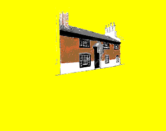
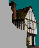
This is the two storey
jettied cross wing of a hall house, the hall long
since demolished. The crown post roof and details
of doors and windows recorded when the house was
refurbished in the 1960s show that it was built in
the first half of the15th century.
|
18 Lower
Dagnall Street today and drawing showing the hall
reconstructed
|
|
|