|

|
Fullers
Street
|
|
|
The present Mud Lane by Westminster
Lodge sports centre was known as Fullers
Lane in the C17. This seems to have been
the Fullers Street of medieval times. In
1266 a plot of land in this street was
said to adjoin the tentorium
(tenterground - a place where the
fulled cloth was hung out to dry) of
Richard son of Robert. In the same year
Alexander Goldstob granted to his daughter
Emma, for ten shillings a messuage and
three particate (?enclosures) of
land and two tentoria in the
Fullers Street, paying yearly 1/2d to
herself and 4d to the Nuns of St. Mary at
Sopwell and 4d to the heirs of John
Woolmonger (lanovii). In 1274 Henry
de Porta had illegally set up a fulling
stock in his house in Fullers Street -
cloth had to be fulled at the Abbey
fulling mill. The cloth trade was of great
local importance. In 1355, 11 weavers, 5
fullers and 2 dyers had infringed
regulations. In the reign of Edward II (c.
1360) there were11 weavers, 6 fullers and
5 dyers. The weavers produced broadcloth,
(a cloth 2 yards by 48 yards). In 1395
there were 27 producers, the 4 most
prolific producing 15, 10, 5 and 5 cloths.
In 1341, 11 men and women held a stock of
15 stone of fleeces. (At St. Mary de Prae
in 1342-3, 6 fleeces were sold for 2s 2d
at the rate of 87 to 15 stone).
Fulling was not the only activity carried
out in this street. In c.1276 Richard of
Waltham, a glove maker, held a messuage
here with pasture, land and one
vineyard.
|
Mills
In the Domesday survey of 1086, 3 mills
are recorded at St. Albans, although
exactly which these were is uncertain.
(see below). The mills did not only grind
corn, there was also a malt mill and a
fulling mill.
|
|
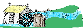
A Medieval Mill
redrawn
rom a manuscript.
Notice the eel traps set
n the stream to take
els heading for the
ea to spawn.
|
|
.
Sopwell Mill
must have been on or near the
site of the existing mill.
Mentioned in 1381 with its
Flotegatestrem and
Mullestrem
Stankfield Mill
was further downstream towards
the site of the post medieval New
Barnes Mill.
Both these were so named in
1119-46 when, along with 2 mills
of Park, they provided eels for
the Abbey kitchen. These were
perhaps 2 of the 3 mills recorded
in Domesday Book in 1086. The
other being the Malt Mill or the
Abbey Mill? Stankfield Mill was
rebuilt in 1326-35.
Ditchmill
Another early mill was
Ditchmill; its location is
uncertain but later it is
recorded as part of the manor of
Kingsbury and in 1194 is
mentioned in the foundation
charter of Prae. It may have been
where Prae Mill was later,
(Its name coming from its
proximity to the large pre-Roman
dyke known today as Devils
Ditch?)
|
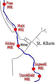
Map showing Location of
Watermills
|
Fulling Mills
Before 1381, as well as
Stankfield Mill and Sopwell Mill
there had been another mill on
that side of the town, recorded
as 'the old fulling mill which
once stood below Eywood',
where it had been in 1247 when
Robert Stanhard was convicted of
stealing woolen cloth from there.
In 1381 the fulling mill was
'below the Abbey' i.e.
Abbey Mill.
|
|
Woods
Eywood
The wood of Eywood stretched from the
edge of the town towards Park Street This
had belonged to the Abbey before the
Norman Conquest and was restored to it by
Abbot Paul (1077-93). At its foundation in
1140 the cell of Sopwell was described as
being next to Eywood, and the wood
seems to have occupied the area between
the river and Watling Street, stretching
to Park Street. Some of the trees were
certainly beeches and mention of pasture
suggest that the trees were pollarded to
provide grazing beneath them. The wood was
broken into by the townsmen in the
troubles of 1326 and 1381. The short lived
Charter of Freedom of the latter year
granted 2 paths through Eywood; 1.- from
Eywood Lane to Park Street and 2. - from
Park Street through the tenements of John
Eywode and Roger Hwcie to
"Stanesfeldmulle".showing that
there were settlements or assarts
in the wood
At Christmas 1423 the Duke of Gloucester
spent the holiday as the guest of the
Abbot but some of his servants poached the
Abbots deer in Eywood. They were punished
by the Duke's own hands!
Deerfold wood stretched over the south
east corner of the former Verulamium. Its
shape on the map is taken from the pattern
of field boundaries on a lte 17th century
map, fields then known as Dorvels, a
corruption of deerfold and the remnant of
wood that then existed. Aerial photographs
of Verulamium show marks which suggest
that at some date trees were grubbed up.
The wood is recorded in 1235-60 when Ralph
Chenduit hunted there with hounds which
led to conflict with the Abbot.
In 1381 the rebels gathered in Deerfold
Field and were summoned to meet Sir Walter
atte Lee, who had arrived with 200 knights
to put down the insurrection, under the
wood of Deerfold. In 1495 Richard Brown, a
weaver of St. Michaels, left to his wife
Joan his lands nd teements in "Dere
Folde Field".
|
|
|